
Updated October 23, 2026
A real-time location system (RTLS) is an indoor positioning system that continuously locates tagged assets, vehicles or people inside a building, where GPS does not work. Small radio tags are attached to what you want to find, fixed anchors or gateways listen to them, and a software platform turns those detections into a live map, inventories and alerts.
We design all three layers in Nantes, France: Bluetooth Low Energy (BLE) tags, anchors and gateways, and the cloud platform. This page explains how RTLS works, which accuracy you actually need, how the main technologies compare, and how we design an indoor positioning deployment.
Why not GPS? Satellite signals barely get through roofs and metal structures. Indoors, a GPS receiver is either silent or wrong by tens of meters. That is why indoor positioning relies on a local radio infrastructure instead.
This is the most important design decision, and the one that sets the budget. Most RTLS projects do not need coordinates: they need to answer a business question such as "where is the ultrasound scanner?" or "how many carts are left in loading bay 3?". A zone answers that question.
| Level | What you get | How it works | Typical use |
|---|---|---|---|
| Presence | The asset passed a point | One reader at a door, dock or washing station | Gate control, wash logging, entry and exit |
| Zone (room-level) | The room, aisle or area the asset is in | One or more BLE anchors per zone; each tag is assigned to the anchor that hears it best | Equipment search, inventory by zone, utilization |
| Point (sub-meter) | X/Y coordinates within 30 cm (1 ft) | BLE angle-of-arrival (AoA) anchors measure the direction of the signal | Workstation-level tracking, automated flows, picking |
An honest rule: with standard BLE anchors, a tag is located by the zone that hears it, not by a point. If a supplier promises point coordinates from simple beacons and signal strength alone, ask how they measure it. Point-level accuracy requires AoA (or UWB) anchors, which cost more and need power at every anchor.
| Technology | Typical accuracy | Tag power | Infrastructure | Best for |
|---|---|---|---|---|
| BLE (signal strength) | Room or zone | Coin cell, several years | Light: anchors every few rooms, battery or mains powered | Large fleets of assets, zone inventory, hospitals, workshops |
| BLE angle of arrival (AoA) | Down to 30 cm (1 ft) | Coin cell, several years | Powered antenna-array anchors, mostly ceiling-mounted | Precise flows, workstation-level tracking |
| UWB | 10 to 30 cm | Larger battery, shorter life than BLE | Dense, powered and synchronized anchors | Robotics, high-precision vehicle tracking |
| Passive UHF RFID | Presence at a reader, a few meters | None (battery-free label) | Readers and antennas at chokepoints | Gates, docks, high-volume low-cost items |
| Wi-Fi | Several meters | High consumption | Existing access points | Smartphones and laptops already on Wi-Fi |
| GPS / GNSS | A few meters outdoors, unreliable indoors | Large battery | None (satellites) | Yards, roads, between sites |
In practice, sites mix technologies. Our hybrid gateway reads BLE tags and UHF RFID labels in the same device, and our GPS trackers also scan BLE, so the same device is located by GPS outdoors and by BLE anchors inside buildings. For a deeper look at the radio layer, see our guide to Bluetooth Low Energy (BLE).
| Layer | Product | Key specifications |
|---|---|---|
| Tags | Battery BLE tag | Ø 44 mm, 13 g, replaceable coin cell, 5-year battery life at one transmission every 4 s, up to 120 m (400 ft) |
| Tags | Battery-free BLE tag | Battery-free, powered by indoor light from 30 lux, under 1 g, IP65, 50 m (165 ft) range |
| Tags | Hybrid BLE + RFID tag (early 2027) | BLE 6.0 with AoA and Channel Sounding, UHF RFID and NFC in a single 4 g tag |
| Anchors | Battery-powered anchor | Battery-powered, LoRaWAN, IP67, −40 to +80 °C: for buildings and yards with no power or network |
| Gateways | Mains or PoE gateway | Mains or PoE, Ethernet or Wi-Fi: continuous real-time reading |
| Gateways | BLE + RFID gateway | PoE, BLE and UHF RFID in one reader: 250 BLE tags/s, 900 RFID labels/s |
| Indoor + outdoor | GPS + BLE trackers | GPS trackers with BLE scanning, up to 8 years of battery life, IP68 |
The full range, with sizes, ranges and operating temperatures, is on our industrial BLE beacons page. All our tags and gateways also read the iBeacon and Eddystone formats.
The common mistake is to start from the anchors, draw their radio coverage and call those circles "zones". The result is technically correct but useless for the people on site, who do not recognize their departments in a mosaic of disks. We do the opposite.
A project usually starts with a pilot of a few weeks to 3 months on one representative area, with KPIs set from the start such as search time or inventory accuracy, before rolling out to the whole site.
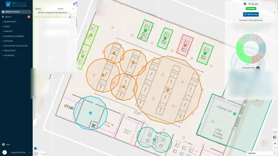
The cost has three parts: hardware (tags and anchors, with volume-based pricing), the platform subscription (based on the number of tracked assets) and installation. Tags cost little each; the budget is driven by the number of anchors, which depends on the number of zones and the accuracy you need. Zone-level BLE needs far fewer anchors than point-level AoA or UWB, and battery-powered anchors avoid cabling costs in existing buildings.
A real-time location system (RTLS) automatically and continuously locates tagged assets or people inside a defined area, usually a building. It combines tags, fixed anchors or gateways, and a software platform that shows positions, inventories and alerts.
Passive RFID tells you that an item passed a reader, for example at a door or a dock. An RTLS tells you where the item is at any moment, even when it does not move. Many sites combine both: RFID for low-cost items at chokepoints, BLE RTLS for equipment that must be found anywhere.
An indoor positioning system (IPS) locates objects or people inside buildings, where GPS is unavailable. It relies on a local radio infrastructure such as Bluetooth Low Energy, UWB or Wi-Fi. "IPS" and "RTLS" are often used interchangeably; RTLS stresses continuous, real-time tracking.
Rarely and not reliably. Roofs, concrete and metal structures block or reflect satellite signals, so an indoor GPS fix is often missing or wrong by tens of meters. Indoor tracking uses BLE, UWB or Wi-Fi instead; our GPS trackers also scan BLE, so they can be located by BLE anchors indoors.
With standard BLE anchors, accuracy is at zone or room level: you know which room, aisle or area an asset is in. With BLE angle-of-arrival (AoA) anchors, accuracy reaches 30 cm (1 ft).
It depends on the number of zones you want to distinguish, not on the floor area. An anchor covers up to 50 m (165 ft) indoors in open space and less in partitioned areas, so count at least one anchor per zone, more where walls and metal shorten the range, plus the corridors between zones. A site survey confirms the count before any commitment.
Send us your floor plans and tell us which assets you need to find: we will propose a zone layout, the number of anchors and a pilot scope. Contact us.

